
The Map of KenshiReport
English:The Map of Kenshi · Locations
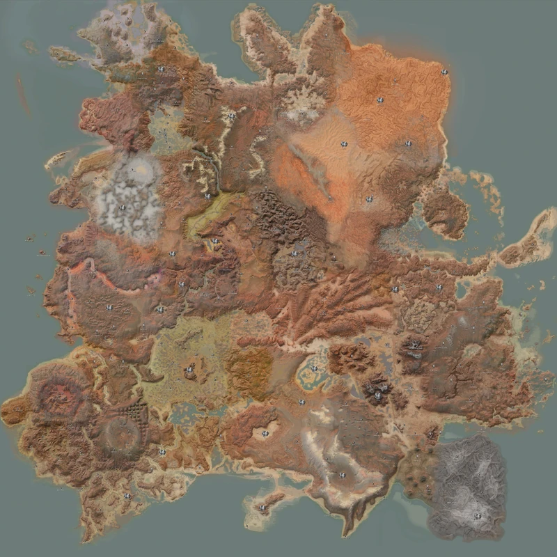
Kenshi's map is a single seamless continent of roughly 870 square kilometres, its surface built from three layers of data (zones, biome map, resource map) — and the notion that tidal locking created its climate belts is a common misconception.
Kenshi's map has no loading screens and no zone transitions; walking from the Leviathan Coast in the far north to the Ashlands in the far south is one continuous journey. The officially advertised area is around 870 square kilometres, billed as the largest single-player RPG world since Daggerfall. What that figure means in practice is this: crossing on foot takes several in-game days, and nothing along the way will adjust the difficulty for you.
The astronomy of this world
Kenshi is not set on a planet but on a tidally locked moon — it keeps one face permanently towards the planet it orbits, so an enormous planet always hangs in the sky. It is the same relationship the Moon has with Earth.
What actually divides the surface is deliberate destruction, and the evidence the game uses is fairly consistent:
- Pollution — the acid rain and acidic ground of the Deadlands, the Iron Valleys and the Black Desert are all explicitly described as the result of heavy pollution, as is the Black Desert's cloud of toxic gas.
- Orbital weapons — a crashed ring satellite lies in the middle of The Eye; the surface burns in Venge come from a second satellite of the same type that is still operating.
- Volcanism — Stobe's Gamble and Sniper Valley share the "Volcano Zone" season, and their biome map codename is literally Batholith. After the Second Empire collapsed, it was ashfall from the neighbouring volcanoes that buried the capital into what is now the Ashlands.
- Sea level change — skeleton characters remark that "there used to be a great port around here, back when the water was hundreds of metres higher than it is now." After the first extinction the sea withdrew, the former islands became hilltops, and the continent expanded.
One reconstruction: not a one-way fall but a rise and fall
That "the sea withdrew after the extinction" account has a competing version. Someone reconstructed ancient water levels from terrain and water-erosion marks and found a pattern: First Empire ruins can be found inside the areas that were once submerged, while Second Empire ruins appear only on the shorelines of those same waters. The sequence derived from that runs: water levels in the First Empire period were not far off today's; the Chaos Age (possibly a nuclear winter) caused a sharp temperature drop and a large accumulation of ice and snow; subsequent warming melted it and pushed water levels up; and a few centuries later they fell back to where they had been[V1 0:11:09].
If that holds, Second Empire cities hug the water because they happened to be built during the high-water phase. It is still inference, but it explains one thing more than the one-way version does: why the two empires' ruins follow different distribution logics.
Put another way, Kenshi's geography is itself a historical ruin. Every stretch of wasteland you cross is the wreckage of something.
This holds true right down to the texture level: crank texture quality to maximum, zoom in on the ground of the Stenn Desert, and what you find is not sand and grit but broken concrete and exposed rebar — the wreckage of the previous megacivilisation, laid directly under your feet[V2 0:08:24]. Some go a step further and speculate that the iron in that rebar, rusted into dust and carried north by the prevailing winds, is the pigment source for the red rain of Vain.
How the map is layered
In the game files, "what you see" and "what happens here" are three independent sets of data:
| Data layer | File | Determines |
|---|---|---|
| Zone | called Spawn Area in the FCS | Spawn tables, seasons, environment modifiers |
| Biome map | biomemap.png | Surface appearance, vegetation, rock styles |
| Resource map | areasmap.tga | Distribution of ores and gathering points |
Their boundaries do not coincide. A single zone may span several biome maps: the Bonefields, for instance, contain both BoneYard and Boneyard Pyramids, while the Spider Plains straddle the Purple Sands and South Coast seasons. Conversely, one biome map may appear in zones that do not adjoin at all — the biome codenamed Dark Finger is used in Darkfinger, Spine Canyon and Fishman Island alike.
At the file level the map is cut into an 8×8 grid of map squares with coordinates from 0,0 to 7,7; each square is further subdivided into a large number of zone.X.Y.zone level files. The Ashlands occupy 6,6, 7,6, 6,7 and 7,7 — the entire south-eastern corner of the map.
The resource layer carries one hard limit: the ore system in the first game is hard-coded. A fixed set of extractable resources is scattered across the map, and mod authors can only add to or subtract from the copper or iron of a given region — new resource types are impossible. Custom resources (gold, say) with matching production chains have to wait for the sequel[V3 0:10:32].
Environment modifiers
Every zone carries a set of values that directly determine whether it is habitable. They fall into two groups:
Environmental (percentages): water, fertility, aridity, greenery, swampiness. Resources: quality ceilings for stone, iron and copper.
A few representative comparisons:
| Zone | Water | Fertility | Iron | Copper | In practice |
|---|---|---|---|---|---|
| Border Zone | 50% | 100% | 100 | 80 | Farming and mining both viable; the standard first base |
| The Swamp | 200% | 100% | 100 | 100 | Water to the point of flooding; swamp crop yields are enormous |
| Vain | 100% | 75% | Low | 100% quality | A copper paradise, but iron is dreadful |
| The Great Desert | 20% | 75% | 100% | 70% | Hard to farm, plenty of ore and stone |
| Ashlands | 0% | 0% | 300% | 300% | Nothing will grow at all; triple ore |
The Ashlands figures deserve a separate look: water and fertility both at zero, iron and copper at 300% each. It is the only extreme combination on the map — a place that does not welcome life but is stuffed with industrial feedstock, which corresponds exactly to its identity as the Second Empire's heavy-industrial capital.
Seasons and weather
A year in Kenshi is 100 in-game days. Each zone is bound to between one and three "seasons", and the season determines which weather appears, in a fixed order and duration. Most zones have only one season and a few have two or three — Skinner's Roam, for example, has three (dust storms approaching / clear / mixed clear and storm), while the Burning Forest alternates between "acid rain forest" and "falling leaves".
Weather splits into the purely decorative and the kind that does actual damage. There are only four of the latter: acid rain, burning, dust storms and toxic gas. For detailed values and protection lists see zone danger ratings.
Blanks and edges
There is one unnamed area on the map, whose internal codename is simply NONE. It covers large stretches of outer coastline and the fringes of the Ashlands, and has no resources, no nests and no enemy spawns at all. The Sonorous Junk Reef and the None Coast are of the same character — they are the map's negative space, and can be used as safe corridors.
Several offshore islands surround the continent, reachable only by swimming: Raptor Island, Forbidden Isle, Fishman Island, Howler Maze and the Islands of None. Forbidden Isle holds the spider factory that is the source of skin spiders; Howler Maze is packed with crabs.
Fog of war and map items
The player's map starts empty, and locations have to be unlocked either by walking to them or by reading a map item. Map items come in two kinds:
- Purchasable: these unlock publicly known settlements. The Glorious Holy Map unlocks every Holy Nation facility, the Map of the Shek Kingdom unlocks Admag, the Great Fortress, Last Stand and Squin, and the Map of Vain unlocks the Hive Villages.
- Loot only: found only in ancient ruins, unlocking lost locations. The Map of the Ashlands randomly unlocks one of the four Ash Domes or Cat-Lon's Exile, while the Bugmaster's Map points straight at Cat-Lon's Exile — because that is the Bugmaster's nemesis.
The Old World
The current map is not Kenshi's original. The whole thing went through a major revision during development, and players call the pre-revision version the "Old World"; a fair number of its locations, factions and items have been removed entirely. The Old World is still accessible through Steam's legacy beta branch, but it is incompatible with the lore of the current version, so cite it with care.
Related articles
Locations of Kenshi, Zone Danger Tiers, Ashlands, The World of Kenshi, History of Kenshi, Game Mechanics
Video citations
- The Origins of the CannibalsHeroInHisHead
- Why is Vain Red? - The Science of KenshiHeroInHisHead
- Kenshi 2 Just Got a New Update!HeroInHisHead